The Shortcut That Looks Short on the Map
A shortcut that looks short on the map can still demand awkward crossings or uncertain access. Compare the whole route before choosing a safer line.
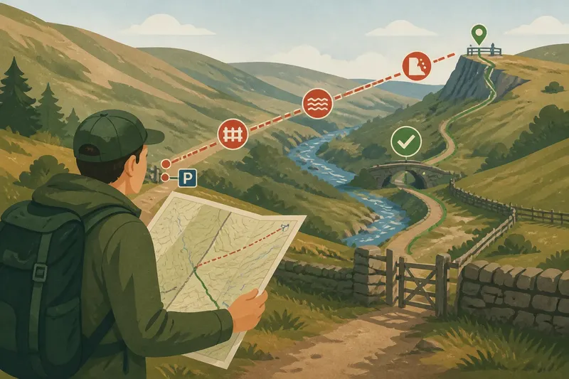
You are standing beside a broad track, looking across a valley at a viewpoint that seems close. The map shows a shortcut crossing the hillside, but its neat line gives no clear answer about obstacles, access or how easily you can follow it on the ground.
For a shortcut that looks short on the map, compare the whole crossing with the established route, not just the distance between its ends. A useful decision comes from checking what lies along the line and what information the map cannot provide.
What a straight line leaves out
A straight line shows direction and horizontal separation. It does not show whether a fence blocks the way, whether a stream is awkward to cross, or whether the ground offers a clear passage.
Measuring the line and the track can help compare their mapped distances, but neither measurement settles which route is practical. A track may bend to reach a bridge, gate or suitable crossing; a direct line may meet an obstacle with no obvious way through.
Keep distance separate from access and terrain. That stops a compact line from being mistaken for an easy route.
Trace the crossing
Follow the proposed shortcut from start to finish, checking each place where it meets a feature that could change your route. Look for streams, gullies, cliffs, marsh symbols, walls, fences, roads and dense vegetation. Use the map legend to interpret symbols, since conventions vary between maps.
Check whether a path or track actually connects the two places. A line with no mapped path may still be crossable, but the map alone cannot establish that it is permitted or sensible. Look for current access information and a reliable local route description when either point is uncertain.
Imagine Sam wants to walk from a car park to a viewpoint across a valley. The map shows a direct line crossing a stream and meeting a boundary, while the established track reaches a marked crossing and gate. Sam checks the legend and current access information, finds no confirmed crossing on the direct line, and chooses the track; the observable result is a route that follows mapped access points rather than relying on an uncertain passage.
Check the route evidence
A map is a selective picture of the ground. It may omit small obstacles or show features whose condition has changed, so use more than one source when the decision depends on a specific crossing or access point.
- Stream crossing: Check whether the shortcut meets a marked bridge or crossing. If one is shown, compare its position with the route; if not, check a reliable local source or choose a route with a known crossing.
- Boundary: Check for walls, fences and gates along the line. If a gate or permitted crossing is identified, follow that access; if the boundary has no clear crossing, avoid assuming you can pass through it.
- Cliff or gully: Check whether the line meets a steep-sided feature or channel. If the map shows a clear way round, use it; if the passage is uncertain, choose an established alternative.
- Path connection: Check whether mapped paths join the start and destination. If they do, compare their route with the shortcut; if they do not, treat the direct line as off-path and seek dependable local information.
- Map detail: Check the scale, legend and date or currency information available. If the map lacks detail for a critical feature, consult a more suitable current map; if no reliable detail is available, do not rely on the shortcut.
- Conditions and group: Check whether poor visibility, wet ground or a companion’s experience could make an uncertain crossing harder. If conditions or ability make the route less manageable, use the clearer established path; if they do not, still confirm access and passage.
Where access rules apply, consult the relevant official or local source. Do not infer permission from a blank patch on the map.
Questions about shortcuts?
Does a direct line always save time?
No. Obstacles, detours and uncertain crossings can make a compact line impractical, while a longer track may connect useful access points. Compare the route on the ground, not only its outline.
Can a map confirm that a crossing is passable?
A map can show a bridge, path or other feature, but it may not describe its current condition. If the crossing matters to your decision, check current reliable information and choose another route if uncertainty remains.
What should I do if no path is mapped?
Treat the line as an off-path possibility rather than an established route. Check access information and the nature of the ground; if either remains unclear, use a known path.
Choose the supported route
The direct option is not automatically unsuitable. It can make sense when the map and reliable access information indicate a clear, permitted passage and the ground presents no unresolved obstacle. If those conditions are missing, the established route offers a more defensible choice.
For a shortcut that looks short on the map, trace the whole line and identify the crossings, boundaries and sources of uncertainty before setting out. A route earns its place through evidence of a usable way through, not simply because it draws a straight connection between two points.
Carry the map or navigation tool you need to follow your chosen route, and be ready to turn back if the ground does not match the information available. A sensible alternative is part of the plan, not an admission that the original line was nearly good enough.