A Familiar Neighbourhood, Drawn from Memory
A neighbourhood map drawn from memory reveals what you notice and what you miss, then a map comparison helps you sharpen local route awareness.
You sit at the kitchen table with a pencil, thinking you could draw the route to the corner shop without looking. A neighbourhood map drawn from memory is a quiet afternoon exercise, but it becomes more revealing when you choose the right starting point and compare your sketch with a street map afterwards.
The aim is not to make a neat or complete map. It is to notice which landmarks, turns and connections you carry in your head, and where your mental picture differs from the mapped area. Choose the approach that suits your mood: a quick sketch, a route-focused drawing or a more detailed neighbourhood map.
Choose your starting point
Begin with the place you know best. If you want an easy, relaxed exercise, draw from home and include the streets you use often. Familiar routes give you reliable points of reference, while the gaps between them reveal what you rarely notice.
If you would rather avoid putting a home address on paper, start at a public place such as a library, park entrance or bus stop. This works well if you plan to keep the drawing or show it to someone else. Mark the starting point clearly, then sketch the paths you can recall without checking a phone or map.
For a shorter session, choose one everyday journey, such as the walk from a café to a playground. A limited route is easier to hold in mind and makes it simpler to spot whether you remember the order of streets and turns. Pick a route you know from walking rather than one you usually travel by car; the view and route decisions may differ.
Set out plain paper, a pencil and an eraser. Leave a margin for notes, and keep the first drawing untouched until you have finished comparing it with a map.
Draw by landmarks
Put the starting place on the page, then add landmarks that help you orient yourself: a bridge, a row of shops, a school gate, a green space or a distinctive junction. Connect these with streets and paths, even if you are uncertain about their exact shape. A clear relationship between places matters more than a polished street plan.
Use labels rather than elaborate symbols. Write “park entrance” or “traffic lights” beside a mark so you can tell what you meant later. If two places seem close in your memory, draw them close; do not adjust their positions to make the page look balanced.
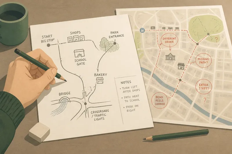
Say you routinely walk from a bus stop to a bakery and then to a small park. You might first draw the bakery before the road bend because that is how the route feels in memory. When you compare the sketch with a street map, the bend may appear before the bakery, showing that your remembered sequence has compressed part of the walk.
Add an arrow for north only if you know which way it lies. Otherwise, leave the page unorientated and record that choice. The comparison will be more useful if you distinguish a known direction from a guess.
Match the exercise to your situation
If you want a gentle activity: draw only familiar landmarks and the paths joining them. This is a good fit when you have little time or do not want to turn the exercise into a test. Leave uncertain details blank rather than stopping to solve them.
If you are curious about route memory: sketch one journey from start to finish, including each turn and any decision point. This suits someone who wants to understand how they recall a particular walk. Add a small mark wherever you remember choosing between routes, such as a crossroads or path entrance.
If you are drawing with a child or another person: agree on a shared starting place and let each person draw their own version. This works well when you want to compare different ways of noticing the same area. Ask what each landmark means to the person who drew it; a place that seems minor on a map may be a strong personal cue.
If privacy matters: use a public starting point and omit home entrances, names and any details you do not want to keep. This is the sensible choice if the page may be photographed or shared. The exercise still works with parks, shops and public crossings.
If you want a more precise comparison: sketch the route first, then add nearby streets and landmarks from memory. This fits a reader who is interested in how the route sits within the surrounding area, not just in recalling turns. Keep the remembered drawing visually distinct from anything added after checking the map.
Compare the map carefully
Once the sketch is complete, open a street map or local map and locate the same starting point. Compare one feature at a time: the order of landmarks, which streets connect, where paths cross, and how the route bends. A map’s symbols and level of detail can vary, so use it to check relationships rather than expecting every small feature to appear.
Look for three kinds of difference. A landmark may be missing because it does not stand out during your usual journey; two streets may be joined differently in your memory; or a route may feel straighter or shorter on paper than it is while walking. Mark each difference with a light pencil note, without erasing the first sketch.
For a useful visual comparison, place the map beside your drawing and turn the pages until the main route runs in roughly the same direction. Do not force the sketches into perfect alignment. Instead, notice whether the same places remain near one another and whether the sequence of turns makes sense.
If the map shows a path that you do not remember, treat it as information to check rather than an invitation to use it. A mapped line does not tell you by itself whether access is open or conditions suit a visit. For this exercise, there is no need to go out and verify every discrepancy.
What does the comparison reveal?
Why do familiar streets appear in the wrong order?
Memory often keeps the sequence that matters to a journey rather than every bend between landmarks. You may recall turning at the shop and reaching the park, while leaving out a side street that you pass without making a decision.
Should I correct my original drawing?
Keep the first sketch as it is, then make a second version if you want a more accurate map. The untouched page preserves what you remembered before looking, while the revised version can show what you learned from the comparison.
What if my map looks very different?
Check whether you have matched the same starting point and route before judging the drawing. If they match, note the biggest difference and consider what you tend to use as a cue: a turn, a building, a change in ground or the next destination.
Can I use a phone instead of paper?
You can draw in a notes app or on a blank digital canvas, provided you do not view the reference map first. Paper makes it easier to leave the first attempt visible beside the map, while a phone may be convenient if you want to save a private copy.
Keep the useful details
After comparing, add a few notes about what you learned: a crossing you had forgotten, a landmark that anchors the route, or a connection you had mistaken. Avoid turning the page into a list of every street. The point is to record details that change how you understand the area.
You can repeat the exercise another afternoon from a different public starting point, or ask someone who knows the same neighbourhood to draw their version. Keep each original sketch separate from the map you consulted, so you can see how your remembered picture changes over time.
A neighbourhood map drawn from memory is most useful when it reflects your own cues, not when it resembles a cartographer’s finished work. Leave one uncertain corner on the page and carry that question with you next time you walk the route.